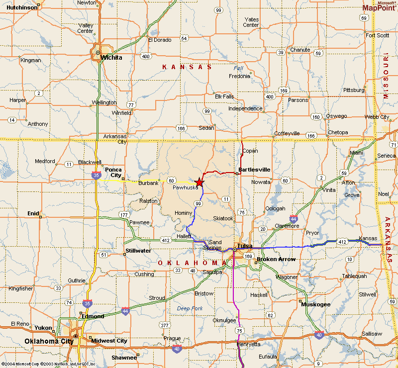
 Click on the map on the left to get a larger view. We have listed some directions to get to Pawhuska from several different directions. These are suggestions, there are many ways to get to Pawhuska. The Municipal Airport is about 4 miles West of town.
For area details and lodging check out www.pawhuskachamber.com
Coming from the North or South via I-35 (i.e. Wichita, KS, or Oklahoma City, OK)
(yellow route on the map)
Follow I-35 to exit 214 (US-60/Ponca City)
Turn East onto US-60
Follow US-60 East for about 53 miles.
Pawhuska Municipal Airport is about 4 miles West of the City.If you get to Pawhuska before you see the airport, you went too far.
Coming from the East via I-44/I-244/US-412 (i.e. Tulsa)
(blue route on the map)
If entering Tulsa from US-412, follow signs for I-44
Once on I-44 continue to I-244 exit.
Follow I-244 through Tulsa to US-412 (Sand Springs).
Follow US-412 to US-64 (Cleveland) exit.
Follow US-64 West to SR-99.
Take SR-99 North to US-60.
Turn West onto US-60.
Go through town of Pawhuska.The airport is about 4 miles West of town.
Coming from the North via US-75 (i.e. Independence, KS)
(red route on the map)
Go South on US-75 to Bartlesville.
Turn West on to US-60 in Bartlesville.
Follow US-60 to Pawhuska.
Go through town of Pawhuska.
Airport is about 4 miles West of town.
Coming from the South via US-75 (i.e. Okmulgee)
(purple route on the map, that merges into the blue route)
Follow US-75 North to I-244.
Take US-412 West (Sand Springs) exit.
Follow US-412 to US-64 (Cleveland) exit.
Follow US-64 West to SR-99.
Take SR-99 North to US-60.
Turn West onto US-60.
Go through town of Pawhuska.Airport is about 4 miles west of town.